With the enactment of the current Forest Code (Law No. 12,651/2012), the Rural Environmental Registry (CAR) was established as a national, mandatory, electronic public registry for all rural properties. Its purpose is to integrate environmental information about rural properties and holdings, forming a database for environmental and economic monitoring, control, planning, and the fight against deforestation.
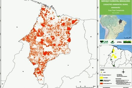
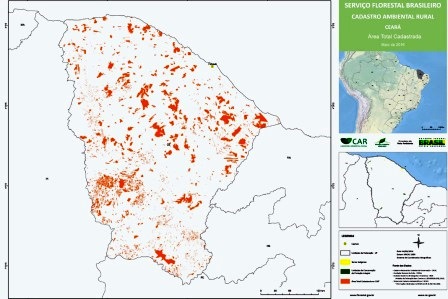
The CAR consists of the electronic registration of georeferenced spatial information of rural properties, including the delineation of Permanent Preservation Areas (APP), Legal Reserves (RL), remnants of native vegetation, consolidated rural areas, and areas of social interest and public utility. The objective is to create a digital map from which area values are calculated for environmental diagnostics. Registration is carried out through the submission of this information in the National Rural Environmental Registry System (SICAR).
After registration, as established by Decree No. 7,830/2012, the competent state environmental authority performs the analysis and validation of the records. If pending issues or inconsistencies are identified in the information declared or in the documents submitted, the applicant is notified to provide additional information or correct and adjust the submitted data. At this stage, the authority may also request enrollment in the Environmental Regularization Program (PRA).
The CAR and PRA are, therefore, important instruments for promoting the restoration of vegetation cover, and their effective implementation contributes to Brazil’s commitments regarding greenhouse gas emission reduction targets under the Paris Agreement. Moreover, the environmental restoration of deforested or degraded areas ensures the maintenance of environmental services such as climate regulation and the preservation of water bodies.
This project contributed to the implementation of the CAR by producing a georeferenced database on land‑use and land‑cover in the Amazon biome, suitable for integration into SICAR, thereby supporting the stages of CAR analysis and validation carried out by state governments.
The project aimed to support the process of environmental regularization in the Amazon biome through: (i) mapping land use and land cover; (ii) calculating environmental liabilities in Permanent Preservation Areas (APPs) along watercourses and identifying areas with potential for restoration in conservation units and Indigenous lands; and (iii) integrating geospatial database information into SICAR.
The project was aligned with the “Monitoring and Control” (2) and “Science, Innovation, and Economic Instruments” (4) components of the Amazon Fund Logical Framework.
Its direct effects were defined as “structured and modernized environmental monitoring, control, and accountability institutions in the nine states of the Legal Amazon” (component 1) and “knowledge and technologies aimed at the conservation and sustainable use of biodiversity, the monitoring and control of deforestation, and territorial planning produced, disseminated, and used” (component 4).